988 Nouvelle Calédonie: June-July 2018
Lifou – Ouvéa – Île des Pins (12 days)
Lifou (Drehu) Island is the largest and most heavily populated of the Loyalty Islands and with its 1200 km2, it’s praised as the largest atoll in the world. This is not fully correct … it’s actually a makatea (a raised atoll), an ancient lagoon slowly raised by geological processes. Lifou consists of a wide, flat plateau covered by forests. The entire island is a large limestone karst with no surface water; only through a complex system of caves you can access the deep freshwater reservoir. These caves were used in the past when searching for fresh water, and are very important to the island's mythology.
We landed at the Aérodrome de Wanaham under heavy rain. Once out of the small airport building, we saw hundreds of rental cars parked on a small space. Unfortunately for us, we forgot that it’s school vacation and the peak of the wedding season! … no cars available on the entire island! Besides, the island is too large to get around on foot … well, we'll have to arrange something for our 3-day stay here.
The day after, Jordan, the owner of the hotel, drives us around the island: Les Falaises de Xodre, the beautiful Plage de Joj, Plage de Luengöni, Les Falaises de Jokin, La Baie de Jinek and to finish at the Plage de Luecila. Despite the morning rain, we could walk around and take a short swim in Luengöni as well as a good snorkeling at Jinek, with its nice coral garden … although with some damages due to the many Australian cruise ship passengers coming here.
On our second day, we take a hypogeal tour: we visit the Jila cave in the tribe of Wedrumel. As it’s a tribal territory, we need a guide (Jeanne) to access the cave. We also need permission from the ancestors for this. We stay 3 hours underground in the cave, visiting about 2km out of the total length of 6 km. The longest known cave on the island is 16 km long. It’s a fascinating cave with some fossils, a few historical artifacts made by the ancient Kanaks and some nicely decorated chambers.
1
It’s time to fly to Ouvéa (Iaaï), the ‘island closest to paradise’ as described by the Japanese writer Katsura Morimura in the 70’s. The atoll has modest dimensions: 35 km long and in some places less than 40 m wide! The atoll has a single road running North to South, along the endless beach that faces the lagoon. Ouvéa is preserved from urban modernity and the life is driven by tribal traditions and customs. Ouvéa counts 4,300 inhabitants whose ethnic heritage stems from Polynesian and Melanesian migrations. This is why two different indigenous languages are spoken on Ouvéa: Iaaï, a Kanak language, and Faga-uvea, which is of Polynesian origin.
Our first stroll is along the 25 km Fayaoué Beach, a gorgeous white coral sand beach. We stop at the Pont de Mouli: from this road bridge you can see plenty of rays, turtles and fish swimming beneath you at low tide, when the sea flows out of the Baie de Lékiny into the lagoon. Unfortunately, you cannot swim in this beautiful area of the lagoon as it is a custom protected area. We continue our walk until the tribe of Lekiny. On our way back, we follow the now suddenly busy road: a Polynesian wedding is ongoing! We arrive at the Pont de Mouli just in time to see the freshly married couple taking pictures on the beach.
On our second day, we take the boat with Pierre to the Southern Pléiades for a snorkeling tour. We start from Baie de Lékiny, then under the Pont de Mouli to reach the Southernmost point of the island: the Pointe de Mouli, our first snorkeling spot of the day. The water is quite deep in this point 20-40 m but very clear. We take a tour … not really interesting until we see a huge ray manta, probably 4-5 m wide lying about 20 m below us … very impressive ... we continue our snorkeling tour watching our back to check the two big sharks that are approaching!
The next snorkeling site is the coral garden at the Passe du Coëtlogon: this place is simply magnificent … you cannot describe it … an incredible biodiversity of corals displayed in thousands of colors. It’s nearly impossible to clearly watch them, you get lost in this unique wonder world of forms and colors, a surreal, magic and fabulous dive! We then stopped along the cliffs of Motu Gece to take our lunch aboard. After lunch, we wait for the sharks to find us … of course they were on time and started to circle around the boat. Unfortunately, time is over and we have to return to the Baie de Lékiny.
Our last day is spent along the beach where we walk until the tribe de Mouli in the very South approx. 10 km both ways. An endless beach without hardly anyone …
2
Our next island is Île des Pins (Kunié), boasting large beaches of white sand and clear turquoise waters, especially the neighboring Kaa Nuë Méra Bay and Kuto Bay. This time, it was not an issue to find a rental car, so we can drive around as we like.
We were quite disappointed by the ”famous” snorkeling spot in Kaa Nuë Méra Bay … nothing to see there. Only in the small “protected” area, you see some corals and fish but there is no diversity: everything is exactly of the same species. Very clearly too many tourists are coming here. Fortunately, we found another, less accessible bay with some untouched reefs for a good snorkeling. The white sand is so fine and soft as talcum … a pleasant sensation when walking barefoot.
The center of the island is occupied by a raised plateau whose highest point is the N’ga Peak (262 m). The weather looks good for this one-hour walk. The easy-to-find path begins from the main road, crosses the forest and then steeply follows the slopes of the N’ga Peak. From the summit, there are fantastic views over the entire island, the smaller islets and its turquoise bays. All around the island, you will see huge rocks or islets, which seem to be literally balancing on the water, like gigantic floating buoys.
For the descent, we increase the pace … big black clouds are coming up and we make it just in time to the car.
The natural swimming pool of Oro Bay is certainly the major icon of Île des Pins. Separated from the sea by a barrier of rocks, this ultra-clear swimming pool is a natural extravagance. In the turquoise waters, coral heads and a little fringing reef let you admire the multi-colored giant clams. As the tide rises, the fish get pulled into the pool by the strong current and you will suddenly see big schools of fish. On the way back, we walk along the slender river of sand at low-tide before having lunch at the shack on the Northern Beach of île Kô Ngéaa Ké.
Of course, La Piscine is the place where you find a lot of tourists. It’s also the place where Le Méridien hotel is built. If you like to avoid the imposed entry and parking fee to the site, you better use the free parking at Le Méridien and follow the path from there, less crowded and for free!
3
Grande Terre (1495 km and 26 days)
Grande Terre is by far the largest island of the Caledonian archipelago, it has an area of 16’890 km2. An impressive mountain range runs along the entire length of the island with the highest peak being Mont Panié at 1628 m.
Grande Terre is the northernmost part of the almost entirely submerged continent Zealandia. Thus, unlike most of the islands in the Pacific, it’s not of recent volcanic origin but continental. Grande Terre has the planet's largest known outcrop of ultramafic rock, originated from an upthrust fold of the deeply underlying mantle of the earth. These ultramafic rocks (peridotites and serpentinites) covered once nearly all of Grande Terre, but have been reduced by erosion and cover today about one third of the island. These metal-rich rocks are a primary source of nickel, chromium, iron, cobalt, manganese, silver, gold, lead and copper.
The mining industry, especially nickel, is the major exporting sector in New Caledonia. The Caledonian nickel resources account for about 15% of the world’s total.
Due to the omnipresence of the mining industry, we decided to visit the Plateau Mine near Thio, the oldest open pit mine in the world still in operation. The Thio mining center has been operating since 1880, and is the historic heart of the nickel mining in New Caledonia. The tour of the Plateau Mine, the only visitable mine in NC, is organized once per month! Unfortunately for us, the tour was canceled last minute, when we were already driving to Thio!
We used that day to visit the town of Thio, the Japanese cemetery (the first Japanese workers for the nickel mining arrived on 25-Jan-1892), the black beach of Ouroué, Mwara beach, the bulk terminal for the nickel minerals as well as some ancient petroglyphs.
After 2 days of uninterrupted rain, we try a hike near Dumbéa. The Dumbéa Provincial Park, opened in 2013, is designed to protect the watershed of Nouméa and Dumbéa. The Dumbéa river with its beautiful gorges upstream provides stunning swimming spots that are very popular during the weekends. The North branch of the Dumbéa River has many emerald green pools. We followed the trail that goes along the North branch and leads to the “Marmites du Diable”. It’s a 6.5 km long hike (one-way) from the parking spot with two river crossings. It’s an easy large and flat trail that follows an older, now closed, 4x4 track. We finally found a nice place to be in New Caledonia, an otherwise quite boring landscape with its monotonous bush-covered hills.
After many days of rain, the end of our stay in NC is approaching. Thus, we decide to break up for our long-planned big tour in the North of Grande Terre. Our first stop is at the Aérodrome de Poé, 175 km North of Nouméa and 17 km West of Bourail. It’s a very small airport with a small strip but more than sufficient for our ULM Pipistrel to take off. Indeed, the weather this morning is cloudless and the wind allows a very clear view. It’s perfect to fly over the most beautiful section of the Caledonian barrier reef: the famous “récif lenticulaire” (reticulated reef), stretching from Baie de Nessadiou to Baie de Moindou. We’re both incredibly excited for this flight, the view is fantastic, magnificent, splendid, superb … We’re lost for words … We see many families of the shy dugongs, the lagon de Poé Déva, Baie des amoureux, Baie des tortues, la Roche Percée, île verte, la faille aux requins … it’s a unique experience with a rare blue sky. We may have seen 3 to 4 times a completely blue sky in NC during our 3 months, and today it’s such a day … but not for long … just after landing the first clouds descend over the mountains and at night, it rains again! We can dream about the many feelings and excitements of this very intense day.
Under the persistent rain, we continue our drive along RT1 to the North. Near Pouembout, we take the winding RPN2 to cross the mountain range to the East of Grande Terre: the Koné-Tiwaka. We stop at the Chutes de Pombei, a small waterfall crossing an outcrop of green and purple colored rocks, mainly serpentinite and metasediments.
In Hienghene, the lagoon is surrounded by impressive black cliffs. In the middle of the bay, we have the Poule Couveuse (Laying Hen), on land the Mont Panié (with 1628 m the highest point in NC), to the North the waterfall of Tao, the picturesque ferry on the Ouaième and several trails that lead to the tribes of Ouayaguette, Bas and Haut Coulna.
Then, we drive to the South and stop in Poindimié on the RT3. Despite the stormy weather, we go snorkeling at the Ilôt Tibarama. The small boat is jumping from one wave to the next, impossible to take pictures without falling into the rough sea. Once arrived on Tibarama, we’re left alone on the island: we have a couple of hours before the dinghy picks us up again. It rains, it’s cold and windy but we jump into the sea … it’s a surreal feeling with this dark and stormy weather in trying some snorkeling… We’re crazy! The water is of course not very clear to take any pictures, so the focus is on macro-photography of small corals … but how to hold the camera firmly to focus on millimeter small details when the waves are meter strong? For every single picture: need to dive, grasp a rock on the bottom and try to take the picture with one hand with very little available light … impossible task but still a few decent pix came out! With the added bonus of a couple of fingers bleeding due to the knife sharp reef ...
Since April, we’ve been waiting for a sunny day to visit the pretty Ilôt Maître, which is a little further than the Île aux Canards. Finally after 3 months, that day arrived … sunshine, deep blue sky, no clouds around, and the sea is absolutely flat like a mirror … it looks surreal. It’s a Monday, winter time and we’re outside of school vacations: there are very few people on this otherwise busy island with its big luxury resort occupying half of the island.
Contrary to Île aux Canards, which is a cay, Ilôt Maître is a sand island, with a lot of seaweed all around it. So, it’s ideal to see turtles like at Phare Amédée. We know also about the “secret” and only place with a very nice coral garden and a lot of fish.
It’s cold water (23 C) and the air outside is not much better (24 C) but it’s crystal clear underwater-view, perfect for the first snorkeling tour at low tide. We cannot understand those people (99.9% unfortunately) that walk out and crush the corals in order to have 1 m deep water to start to swim. They have no clue what it means snorkeling! We start and land from the shore and swim out in less than 30 cm shallow water, without ever touching the ground!
Out in the sea, in the “secret” bay, we observe a wide variety of corals in thousands different colors and hues, many of them we have not seen so far. We also see a huge diversity of fish and 5 green turtles, and of course one golden tricot rayé.
Without the waves and boats, and no people around us, we can clearly hear the crunching sounds of the parrot fishes biting with their robust teeth the coral! A single parrot fish can produce around 400 kg of white coral sand every year. So you know now, where those stunning white beaches are coming from … out of the sphincter of a fish!
It’s our last week in New Caledonia and we’re very happy to have found -finally- the perfect conditions for a fantastic snorkeling day. After 4 hours in the chilly water, we’re shivering and are under-cooled as we did not use a wet suit but we’re incredibly happy for this unforgettable snorkeling day. Admiring the fragile submarine world in the Caledonian Lagoon!
4
5
6
We leave our Caledonian “Home” the beautiful Villa Azur in Robinson, where we’ve been since April 2018
It was an intimate feeling to have this large house for such a long time: we loved it! It was our second longest stay in a single place after Saint Pierre in La Réunion.
We leave New Caledonia with 65 kg of luggage and we have 22 kg more in our storage in Brisbane. We have a total of 87 kg luggage! This is only 5 kg less than our initial 92 kg when we left Switzerland 18 months ago … Sadly, we’re not improving ...
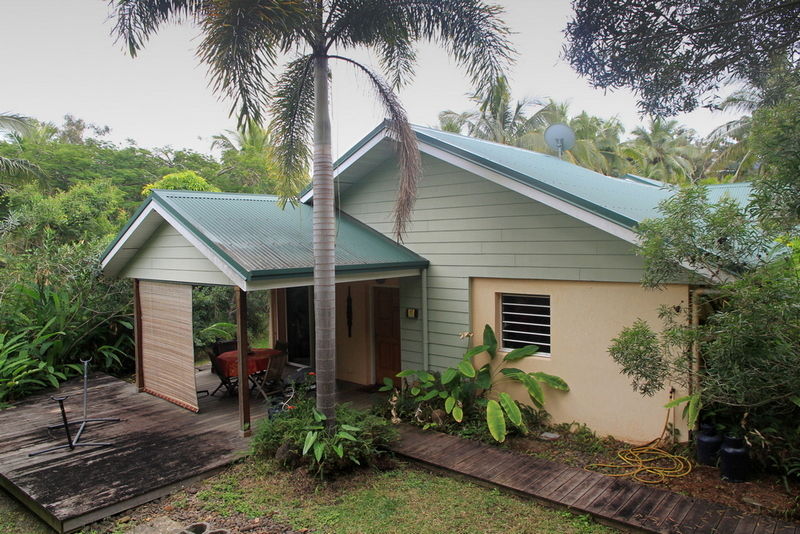 Escale Tropicale, Mont Dore, New Caledonia: our lovely Villa Azur